Unraveling the Zebra Stripes: Tracking Ancient Geomorphological Processes in the Atacama Desert
30 de Abril, 2025
An international research project investigates mysterious striped rock formations on Atacama's coastal slopes—offering new insights into the planet's most arid landscapes and potential extraterrestrial parallels.
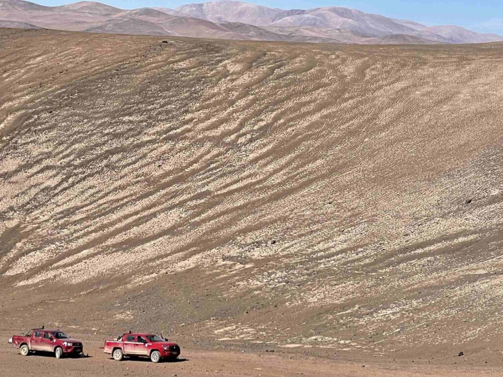
photo_camera A panoramic view of zebra stripe formations on the arid slopes of the Atacama Desert. These distinctive geological patterns show ordered bands of stones that resemble zebra stripes as they descend obliquely down the hillsides. Photo credit: Juan Luis García.
On the arid slopes of the Atacama Desert, a unique geomorphological phenomenon that has puzzled scientists for almost a century can be found. Just a few kilometers from the Pacific Ocean, but at more than 2,000 meters above sea level, hillsides appear decorated with ordered bands of stones resembling the stripes of a zebra. These formations, known as "zebra stripes," represent one of the most fascinating enigmas of the Chilean desert landscape and are the subject of a challenging international research project.
The slow pulse of the desert
When the desert sun falls at the right angle on the steep slopes of the coastal range near Paposo, Antofagasta Region, shadows reveal an astonishing pattern: ordered bands of stones descending obliquely down the slopes forming a geometric pattern that catches any observer's attention.
These formations are not random. The bands are composed of clasts (rock fragments) meticulously organized according to their size, with the smallest at the back and the largest at the front of each stripe, as if they were migrating downhill. They can be arranged perpendicular, sub-parallel, or oblique to the slope, creating a visual effect that has attracted scientific attention since they were first documented in 1927 by German researcher Hans Mortensen.
"The term 'zebra stripes' is more of a nickname, a practical designation that was introduced before (e.g., Owen et al., 2013) and that we use to refer to this particular pattern," explains geomorphologist Dr. Juan Luis García, from the UC Institute of Geography and the UC Atacama Desert Center, who is participating in an international project led by Dr. Simon Matthias May and Dr. Lucas Ageby from the University of Cologne (Germany) that seeks to understand how these stripes form in an environment where geomorphological processes advance with extreme slowness.
Contrary to the popular perception of the desert as a static and unchanging environment, the most recent research suggests that the Atacama landscape is "alive," although its pulse is measured in millennia. "We believe there are significant high-frequency punctuated events that generate changes in desert landforms, as in the case of the 'zebra stripes'."
Our preliminary data and dating Zebra Stripes at a nearby site by Owen et al. (2013) seem to indicate that stripe clasts are exposed at the surface for more than a million years. Paradoxically, however, they are not fossils from a remote past: "The clasts and maybe also the stripes seem to cover the slopes for more than a million years, but that doesn't mean they haven't moved in a million years," explains García, highlighting the exceptional slowness of surface processes and fascinating duality between antiquity and dynamism.
Several paths to a geological mystery
The causal origin of the "zebra stripes" remains a subject of debate, and today there are several hypotheses attempting to explain how these organized bands of clasts formed. Each hypothesis contributes a different piece to a geological puzzle that still awaits resolution through new research, such as the one currently being conducted.
One of the first ideas was water flows: ancient floods in the form of sheet runoff—not channelized torrents—that would have covered the slopes like a blanket of water and sediments, ordering the rock fragments in their path.
Another proposal refers to freezing and thawing. In winter, temperatures can drop enough to temporarily freeze the ground. As it thaws, this cyclical freeze-thaw movement could slowly push the clasts until they form the observed patterns, in a process similar to that of periglacial terrains in cold regions.
It has also been suggested that these formations could be due to the cycles of humidification and drying of the gypsum-rich soil. This mineral has the capacity to absorb moisture from marine air, expand, and then contract as it evaporates, cracking the ground and potentially gradually organizing the stones.
And, finally, similarities with deposits resulting from dry granular flows suggest a possible contribution of seismic shaking to zebra stripe formation as well (May et al., 2019). However, none of these hypotheses can be rejected/verified so far, and it is possible that all of these processes, along with additional factors such as wind, contribute to the formation of zebra stripes. This potentially complex formation mechanism is what the project aims to explain.
Cutting-edge technology to detect imperceptible movement
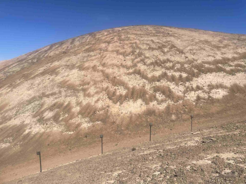
photo_camera Installation of cameras in one of the four work zones of the team. These devices capture continuous images that, through aerophotogrammetric techniques, allow the detection of movements imperceptible to the human eye. Credit: Juan Luis García.
To help solve this enigma, in 2024 the German Research Foundation (DFG) approved a project titled Key mechanisms and chronology of geomorphological processes in hyperarid landscapes. Led by Drs. Simon Matthias May and Lucas Ageby from the University of Cologne, the study includes Dr. Juan Luis García as an associate researcher from the Centro UC Desierto de Atacama.
“Geomorphological processes under extreme hyperaridity are poorly understood, and their rates largely unknown,” explains Dr. García. “This project specifically focuses on studying the processes, factors, and temporal scales behind the production and transport of sediments on slopes in hyperarid landscapes by investigating the so-called zebra stripes.”
The international research team has deployed a range of technologies at three key sites in the Coastal Range. According to García, the aim is “to tackle this geomorphological puzzle with every tool available to test existing hypotheses and open new possibilities.”
At each site, multiple cameras continuously capture images that, using photogrammetric techniques, can detect movements imperceptible to the human eye. In addition, drones are used to generate high-resolution 3D maps, while weather stations monitor local atmospheric conditions.
Advanced dating techniques are also being applied. Optically Stimulated Luminescence (OSL) shall determine whether clasts rotate as they move, while cosmogenic isotope dating using Beryllium-10 will help to establish the general chronological framework of the formations. These samples will be processed both at facilities in Cologne and at the Cosmogenic Isotope Laboratory of the UC Institute of Geography, directed by Dr. García.
“After our first fieldwork campaign, we’ll return to download data from the cameras, conduct another drone survey, and collect more samples,” explains the researcher, referring to the next campaign scheduled for September–October 2025—potentially a critical period for the dynamics of these formations, as the Southern Hemisphere winter ends. “It would be great if we could find some clues and confirm our hypotheses.”
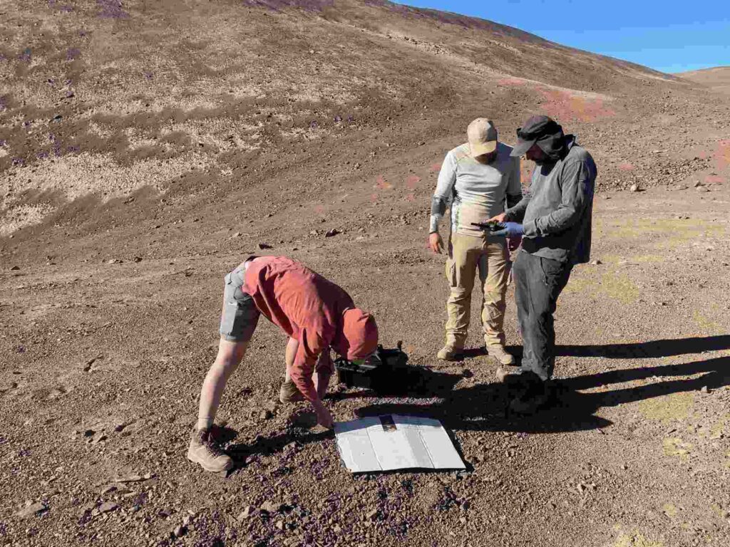
photo_camera The team in the field during a day of work in April. The campaign is part of the project activities in one of the four study areas. Credit: Juan Luis García.
A journey to the past—and the future
While it remains unclear when their formation begun, it is possible that the "zebra stripes" of the Atacama Desert have witnessed more than a million years of Earth's history. Hence, they may have persisted while species evolved and became extinct, and while the global climate oscillated between glacial and interglacial periods. But these ancient formations are not static; they represent a dynamic process that continues today, albeit at a pace that escapes our temporal perception. "The hypothesis is that they are moving, and we want to detect that," comments Dr. García.
Understanding their origin and evolution allows us to reconstruct our planet's geological past, particularly how landscapes evolve under extreme aridity, without an apparent role of biological activity limited by the extreme conditions of deserts, such as the Atacama. In general, the Atacama Desert serves as the closest terrestrial analogue to Mars, and studies on Earth surface processes under this extreme hyperaridity may help to understand the formation of extraterrestrial surfaces.
This research project is led by Dr. Simon Matthias May and Dr. Lucas Ageby of the University of Cologne, with collaborations from Dr. Juan Luis García (UC Institute of Geography and Centro UC Desierto de Atacama), Dr. Anette Eltner of the Technical University of Dresden, and a number of further German and international scientists. It is funded by the German Research Foundation (DFG) (reference numbers AG 432/1-1, MA 5768/6-1).